This Sombori Islands travel guide provides a detailed look at the logistics, landscapes, and cultural nuances of the Southeast and Central Sulawesi frontier. Located across the administrative borders of North Konawe and Morowali, these archipelagos represent a world where the sea dictates the pace of life. The morning sun strikes the water at an angle that turns the sea into a sheet of polished obsidian. Here, in the remote corners of the Banda Sea, the distinction between sky and ocean vanishes, creating a visual phenomenon where boats appear to float in a void of blue. This is the Mirror of the Sky, a place of vertical stone and horizontal infinity.
The journey to this corner of the Indonesian archipelago is not a matter of convenience. It requires a transition from the industrial hubs of Sulawesi to the quiet rhythms of the coast. Most travelers begin the expedition in Kendari, the capital of Southeast Sulawesi. From the airport, a two-hour drive leads through landscapes of palm oil plantations and secondary forests to the small ports of Lapuko or Labibia. Here, the asphalt ends and the water takes over. Wooden longboats, powered by noisy outboard engines, serve as the primary vessels for the three-hour crossing to the islands. As the coastline fades, the muddy greens of the mangroves give way to the deep, translucent indigo of the open sea.
Reaching the Edge of the Banda Sea
The approach to Labengki is marked by a change in the skyline. The horizon, once flat, begins to erupt with the jagged silhouettes of limestone karsts. These geological formations are the defining feature of the region. Over millions of years, the dissolution of soluble rock has created a topography of sharp ridges and deep sinkholes. This specific type of landscape is known as karst.
Karst: A geological landscape formed from the dissolution of soluble rocks, primarily limestone. This process creates a distinct topography of sharp ridges, deep sinkholes, and intricate cave systems. In the context of Sulawesi, these karst formations have been eroded by seawater over millennia, resulting in the vertical beehive islands that characterize the region.
Upon arrival, the air smells of salt and drying fish. The boat slows as it enters the narrow channels between the islands of Labengki Besar and Labengki Kecil. The water is so clear that the shadows of the boat dance across the seabed twenty feet below. There are no large resorts here. Instead, visitors find small guesthouses and homestays that prioritize the view of the water over modern luxuries. The lack of cellular signal and the limited hours of electricity emphasize the isolation. Life here is lived according to the sun and the tides, far removed from the digital noise of the mainland.

Labengki: The Marine Sanctuary of the North
Labengki consists of two main islands and dozens of smaller islets. Labengki Besar is the larger, rugged cousin, uninhabited and covered in dense tropical vegetation. It is home to the Kimaboe Hills, where a steep climb rewards the persistent with a view that mirrors the famous karst landscapes of Raja Ampat. Below the hills lies the Blue Lagoon, a body of water trapped by limestone walls, where the temperature remains cool even in the heat of the afternoon. The water here is a shade of turquoise so intense it appears artificial.
Conservation is a central theme in Labengki. The waters surrounding the islands are a sanctuary for the Tridacna, or giant clam. These prehistoric-looking mollusks can grow to over a meter in length and live for a century. In the shallow flats of the Kimaboe lagoon, a conservation project protects these creatures from poaching. Looking down through a mask, one sees the vibrant mantles of the clams—electric blues, deep purples, and mottled greens—pulsating as they filter the nutrient-rich water. It is a reminder of the fragility of this ecosystem, which remains one of the most biodiverse marine environments in Indonesia.
Beyond the clams, the underwater world is a forest of hard and soft corals. Schools of fusiliers and damselfish move in unison, while the occasional reef shark glides through the deeper channels. The absence of heavy commercial fishing has allowed the reefs to thrive. For those who dive or snorkel, the experience is observational and quiet. There are no crowds, only the sound of one's own breathing and the occasional crackle of parrotfish feeding on the coral.

The Sombori Islands Travel Guide to the Limestone Labyrinth
While Labengki belongs to Southeast Sulawesi, the Sombori Islands lie just across the border in the Morowali Regency of Central Sulawesi. This Sombori Islands travel guide identifies the area as a labyrinth of stone. The transition between the two island groups is seamless, marked only by the increasing height and density of the karst peaks. Sombori is often called the Mirror of the Sky because of its calm, protected lagoons that reflect the clouds with perfect clarity.
The most iconic site in Sombori is the Puncak Sombori, or Sombori Hill. The ascent is treacherous, involving a scramble over razor-sharp limestone rocks that can easily cut skin. There are no paved paths or handrails. At the summit, however, the perspective shifts. The archipelago unfolds in every direction, a cluster of green-capped towers sitting in a pool of light blue water. From this height, the geological history of the region is visible in the way the islands align, tracing the ancient movements of the earth's crust.
Another highlight of the Sombori group is Gua Berlian, or the Diamond Cave. Accessible only by boat and a short climb, the cave gets its name from the way the sunlight hits the stalactites and stalagmites. The minerals in the rock shimmer like crushed gems when illuminated. The air inside is cool and damp, a stark contrast to the humid heat of the lagoons. The silence inside the cave is absolute, broken only by the rhythmic drip of water that continues the slow work of shaping the stone. It is a place that feels ancient, a subterranean cathedral carved by time.
| Feature | Labengki | Sombori |
|---|---|---|
| Administrative Region | North Konawe, SE Sulawesi | Morowali, Central Sulawesi |
| Primary Attraction | Giant Clams & Blue Lagoon | High Karst Peaks & Caves |
| Human Settlement | Large Bajo Village | Seasonal Fishing Huts |
| Topography | Rolling hills and coves | Sharp, vertical limestone |
| Accessibility | 3 hours from Kendari | 4-5 hours from Kendari |
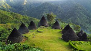
Living with the Tides: The Bajo of Labengki Kecil
No visit to this region is complete without understanding the human element. Labengki Kecil is a small island almost entirely covered by a village of the Bajo people. Historically known as sea nomads, the Bajo have transitioned from living entirely on boats to building permanent stilted houses over the water. The village is a dense network of wooden walkways and narrow alleys. There are no cars or motorcycles here; the only sound is the chatter of residents and the splashing of children who seem to spend more time in the water than on land.
Observation of the Bajo way of life reveals a deep, intrinsic connection to the ocean. Small wooden canoes, known as lepa-lepa, are parked beneath the houses like cars in a driveway. The men are master free-divers, capable of descending to incredible depths on a single breath to hunt for fish or gather sea cucumbers. Their eyes are adapted to see clearly underwater, and their lives are dictated by the lunar cycles that govern the tides. Despite the encroaching modern world, the Bajo maintain a culture that is fundamentally maritime.
Walking through the village, visitors are often greeted with quiet curiosity. Life is public and communal. Women sit on porches cleaning fish or weaving mats, while the local mosque calls the faithful to prayer. The village is a testament to human resilience, a community built on the edge of the world where the land is scarce but the sea is bountiful. It is a place of simplicity, where the value of a day is measured by the catch and the weather.

Essential Gear and Seasonal Rhythms
Planning a trip to these islands requires careful consideration of the seasons. The best time to visit is during the dry seasons, which typically fall between April and June, and again from September to November. During these windows, the sea is calm, and the visibility for snorkeling is at its peak. Between July and August, the eastern monsoon can bring high waves and strong winds, making boat travel difficult and sometimes dangerous. The rainy season, from December to March, brings frequent downpours that can obscure the very views people come to see.
Preparation involves packing for a remote environment. There are no ATMs on the islands, so carrying sufficient cash is mandatory. The sun is intense, and the reflection off the white limestone and turquoise water increases the risk of burns. Travelers should prioritize high-SPF sunscreen, wide-brimmed hats, and long-sleeved water shirts. Dry bags are essential for protecting cameras and electronics during boat transfers, as the open longboats offer little protection from sea spray. Because electricity is often limited to a few hours in the evening, bringing a high-capacity power bank is a practical necessity.
- Waterproof Footwear: Essential for navigating the sharp limestone rocks and shallow reefs.
- Snorkel Gear: While some homestays provide equipment, having a personal, well-fitting mask ensures a better experience.
- Basic Medical Kit: Include antiseptic, bandages, and motion sickness medication for the boat crossings.
- Biodegradable Soap: To minimize the chemical impact on the fragile marine ecosystem.
- Insect Repellent: Needed for the evenings on the islands.
Conservation and the Future of the Archipelago
As tourism grows in Labengki and Sombori, the pressure on the environment increases. The very beauty that attracts visitors is also what makes the area vulnerable. The limestone karsts are easily damaged, and the coral reefs are sensitive to changes in water temperature and pollution. Local initiatives are beginning to focus on sustainable tourism, encouraging visitors to take nothing but photographs and leave nothing but ripples. The Giant Clam conservation project in Labengki is a prime example of how tourism can support ecological preservation if managed correctly.
The future of these islands depends on a balance between economic opportunity for the Bajo people and the protection of their natural heritage. Travelers play a role in this by choosing responsible guides and respecting local customs. The Mirror of the Sky is more than just a destination; it is a living, breathing ecosystem that has existed for millennia. To visit is to witness a rare convergence of geology and culture, a place where the earth and the water are still in a state of primal beauty.
Standing on the shore of a Sombori lagoon as the sun sets, one realizes that the silence is the most profound part of the experience. The sky turns a pale violet, and the water holds the color until the stars begin to appear. In this remote corner of Indonesia, the world feels vast and untouched. It is a reminder that there are still places where the map remains a suggestion, and the journey is the destination.
People Also Ask
When is the best time to visit the Sombori and Labengki Islands?
The ideal window is during the dry seasons from April to June and September to November. During these months, the Banda Sea is calm, and underwater visibility is excellent. Avoid the peak of the monsoon in July and August when boat travel can be hazardous.
How do travelers reach the islands from Jakarta or Bali?
Travelers should fly into Haluoleo Airport in Kendari (KDI). From the airport, take a private car or taxi to the port of Lapuko or Labibia (approximately 2 hours). From there, a pre-arranged wooden longboat will take you to the islands in about 3 hours.
Is there mobile phone signal or internet on the islands?
Signal is extremely limited and unreliable. Some spots in Labengki Kecil may receive a weak signal from Telkomsel, but for the most part, visitors should expect to be offline. There is no public Wi-Fi available.
What kind of accommodation is available?
Accommodation consists mainly of simple wooden guesthouses and homestays. These are usually stilted structures over the water. They provide basic amenities, including mattresses, mosquito nets, and communal or private bathrooms. Luxury resorts do not exist in this area.
Are there any ATMs or places to change currency?
No. There are no banking facilities or ATMs on any of the islands. All transactions are done in Indonesian Rupiah (IDR) cash. It is essential to withdraw enough money in Kendari before heading to the ports.
Do visitors need a guide to explore the islands?
Yes, a local guide is highly recommended and often necessary for navigating the labyrinthine channels of Sombori and for arranging boat transport. Most visitors book a multi-day tour package from Kendari that includes a boat, guide, and meals.